The History Of Punt And The Connection To Eritrea (~2500 BC – 1000 BC)
Preface: Punt is thought to have encompassed areas of Eritrea, Northern Ethiopia, and parts of Northern Somalia, reaching down to Puntland. It is speculated to have been a society of diverse ethnic groups, though establishing a concrete connection to contemporary ethnicities remains, at best, uncertain. While this article focuses on Punt within the northern regions of Ethiopia and Eritrea, it does not negate the likelihood that Punt also included regions of Modern-day Somalia or Djibouti.
The ancient civilization known as Punt has intrigued historians and archaeologists alike due to its mysterious nature and the limited information available. Punt is thought to have existed between approximately 2500 BC and 1000 BC. This timeframe places Punt in a significant historical context, intersecting with the Old, Middle, and New Kingdom periods of ancient Egypt. Despite the many expeditions recorded by the Egyptians to this enigmatic land, the exact location of Punt remains a topic of debate among scholars.
On the left is Myrhh and on the right, Frankincense. (Source)
Punt was renowned in ancient Egypt for its abundant production of Frankincense and Myrrh, earning it the titles “The Land Of plenty” and “The Land Of The Gods” due to its vast resources and the exotic, distant character of its land & people.
Interestingly, Punt was never invaded by an Egyptian military force1, nor did the Egyptians ever establish permanent centres there. This is particularly notable considering the extensive periods, sometimes up to three months, that Egyptians spent in Punt during their expeditions2. This non-confrontational relationship could be attributed to various factors.
Firstly, it appears that the Egyptians found it more convenient to depend on the Puntites for the production and transportation of trade items, instead of trying to conquer and transform Punt into a subject territory. The challenges of navigating the distant location of Punt, along with the perils of sea voyages, probably rendered the idea of a military expedition as impractical and resource-intensive.
Secondly, the Egyptians may have greatly esteemed the Puntites, as they often referred to their land as the “Land of the Gods”. This high regard could have influenced their decision against invasion.
3Frankincense is extracted from the Boswellia tree while Myrrh is obtained from the Commiphora tree. Both are collected by bleeding the trees.
Where was Punt located?
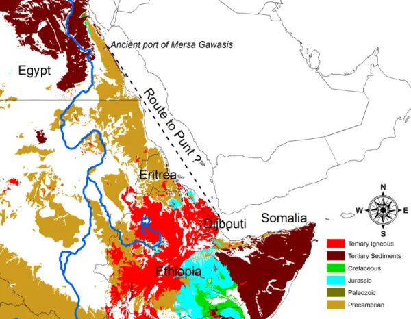
The precise location of Punt remains a topic of considerable debate, with theories suggesting various regions such as the southern Arabian coast, Eritrea, Northern Ethiopia, and Somalia. Currently, a majority of scholars lean towards the view that Punt likely included the territories of present-day Somalia, Djibouti, and Eritrea4. The vague details in ancient writings, along with sparse archaeological findings, continue to fuel discussions on its exact location. In this section, I will explain why Eritrea (along with adjacent areas of the northern Ethiopian highlands) was a crucial component of Punt. However, this does not eliminate the possibility that Somalia was also a significant part of Punt, as it very likely was.
Bia-Punt
What is Bia-Punt?
Punt often acted as an intermediary for other African nations in their trade with Egypt. While little is known about most of these “other” nations, records and research have shed some light on three: Amu, Irem, and Bia-Punt. Among these, Bia-Punt is the most documented and is thought to be a region within Punt5, most likely located in Northern Eritrea. This area was particularly noted for its mining activities, suggesting that Bia-Punt was a significant source of minerals and possibly other valuable resources in the trade networks between Egypt and the African interior.
Sesostris I
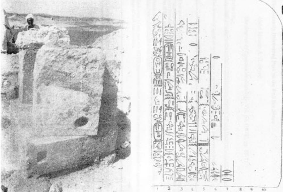
During the reign of Ancient Egyptian Pharaoh Sesostris I (1956-1911 BC), a shrine belonging to an official named Ankhu was discovered. The shrine consisted of three discarded stone anchors, and it contained the following inscription, mentioning the “mining region of Punt”:
Anchors used in the shrine of Ankhu and the inscription from the shrine – Profiling Punt: using trade relations to locate ‘God’s Land’ , pg 27
The Tale Of The Shipwrecked Sailor
The Tale of the Shipwrecked Sailor is among the few intact fictional narratives from the Middle Kingdom. It recounts the journey of a sailor who, after being shipwrecked during a voyage to a mining area, encounters the prince of Punt.
This narrative offers additional proof that trips to Punt extended beyond mere commercial pursuits. It suggests that, besides the trade of incense and luxury African products, Punt was also linked with mining activities. The story of the shipwrecked sailor is as follows:
Please be aware that various translations of the story exist, with each one differing slightly in their interpretation.
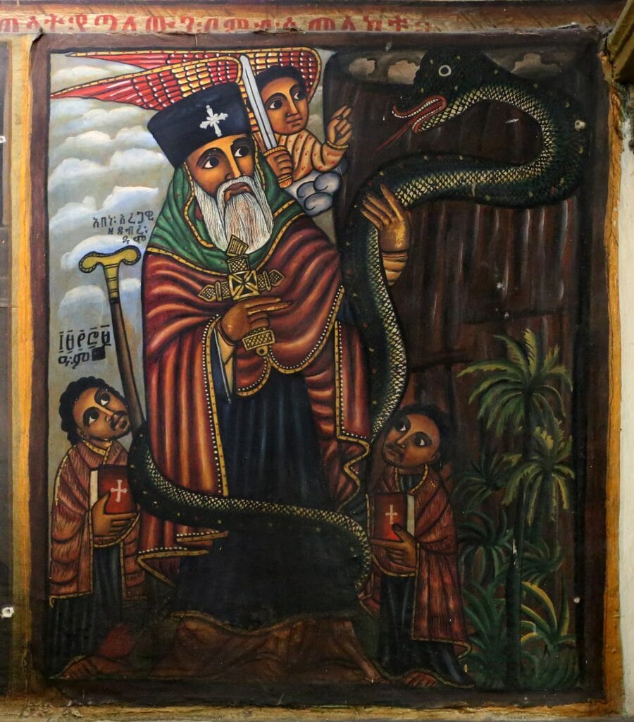
The Story Of The Shipwrecked Sailors mentions a snake prince, which is eerily similar to the worship of the snake arwe which is attested to in Habesha’s prior to the arrival of christianity in the 4th century AD.
Abuna Aragawi riding a large serpant up Debre Dammo – Painting at St. George’s Cathedral, Addis Ababa
Eritrea and Bia-Punt, the connection
6Eritrea stands out in the region due to its geological uniqueness. It is the only territory in Northeast Africa and the Arabian Peninsula characterized entirely by Precambrian formations. This distinction makes Eritrea exceptionally significant from a geological and economic perspective, particularly in terms of mineral extraction and potential mining activities. These Precambrian rocks point to Eritrea, being the mining region of Bia-Punt mentioned in the Ancient Egyptian inscriptions above.
Precambrian rocks are some of the oldest on the planet, forming the Earth’s early crust. These ancient geological formations are known for their potential to contain valuable mineral deposits. In Northeast Africa, areas with old metamorphic (Precambrian) rocks are particularly noted for their gold-yielding potential. The presence of these rocks is a key indicator for geologists and mining companies when exploring for gold deposit7.
Geological formations in Northeast Africa, Precambarian is highlighted in gold.(Source)
Adulis and Ancient Egyptian Baboons
Adulis, located on the coast of present-day Eritrea, was a critical maritime hub that played a significant role in the ancient maritime trade network. Its history can be traced back to at least the first millennium BCE, highlighting its long-standing importance in connecting various civilizations8. This port city was pivotal in facilitating the movement of ships, goods, and ideas among major ancient centres such as Egypt, Arabia, and India. During this period, the exchange of goods and cultural practices among these regions was instrumental in shaping their individual and collective histories.
Hermopolis Magna, currently known as el-Ashmunein, is situated in Upper Egypt and was esteemed as a significant religious centre dedicated to the worship of the god Thoth during the Pharaonic period9. Thoth was venerated as the god of writing, wisdom, and the moon, and held the title of vizier to the gods. His significance in the Egyptian pantheon is reflected in the grandeur and devotion evident in the sanctuary and temple complex of Hermopolis Magna10.
The religious site was famed for its numerous colossal statues, each weighing approximately 35 tons, representing P. hamadryas, a species of baboon, as manifestations of Thoth11.
Statue Of Thoth Erected by Egyptian Pharaoh Amenhotep III, 18th Dynasty, New Kingdom, 1390–1353 BCE(Source).
Eritrea, Adulis and Thoth
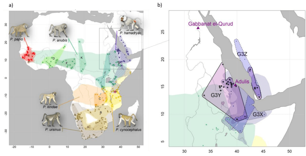
The worship of Thoth and the reverence for baboons in ancient Egypt is further illuminated by archaeological discoveries in the region, particularly in Gabbanat el-Qurud, also known as the “Valley of the Monkeys” in Egypt. Excavations and analyses in this area have uncovered mummified baboons dating from around 800–540 BCE. These findings provide insight into the religious practices and animal mummification traditions of the time.
Significantly, the complete mitochondrial genomes of a mummified baboon from Gabbanat el-Qurud, along with 14 specimens from museums, have been analyzed, revealing a notable connection. The phylogenetic assignment of these baboons links them to modern populations of Papio hamadryas in Eritrea12. This connection suggests that the region of present-day Eritrea, particularly the area around Adulis, was likely a source for the baboons revered and mummified by the Egyptians.
Present-day distributions of six baboon species. The purple highlights P.hamadryas(Source)
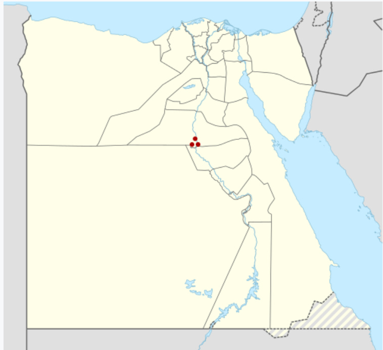
Obsidian at Mersa/Wadi Gawasis, Linked to Eritrea
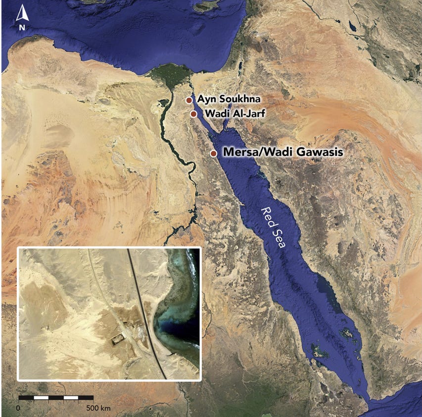
Map of Egypt showing the location of the three Dynastic harbours of Mersa/Wadi Gawasis, Ayn Soukhna and Wadi Al-Jarf, and inset with the satellite image of Wadi Gawasis (Source)
In 2004, the archaeological team led by the distinguished Egyptologists Kathryn Bard and Rodolfo Fattovich conducted significant excavations at Mersa/Wadi Gawasis in Egypt. This site was identified as the ancient port of Saww, which played a crucial role during the Egyptian expeditions to the mysterious land known as Punt13.
Discoveries and Artefacts
The archaeological findings at Mersa/Wadi Gawasis were notable for a variety of reasons. Among the most significant discoveries were a number of commodities believed to have been brought back from Punt. One of the most intriguing finds was obsidian, a type of volcanic glass. Given that obsidian does not occur naturally in Egypt, its presence at the site provided clear evidence of long-distance trade14.
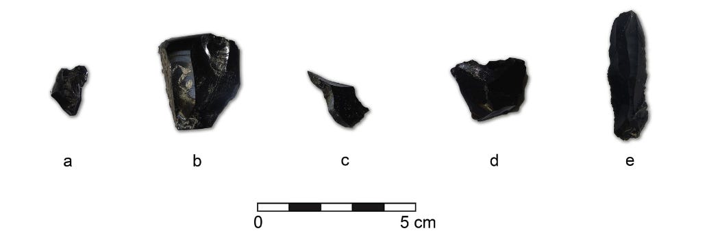
Wadi Gawasis. Obsidian artefacts from the 1976–77 excavations (a: Artefact 1 — chunk; b: Artefact 2 — Sidescraper on flake; c: Artefact 3 — Flake from a multiple platform core; d: Artefact 4 — Fragment of a multiple platform core; e: Artefact 5 — Blade from a single platform core) (photo: G. Lucarini, IAJAE Archive). (Source)
Geochemical Analysis of Obsidian
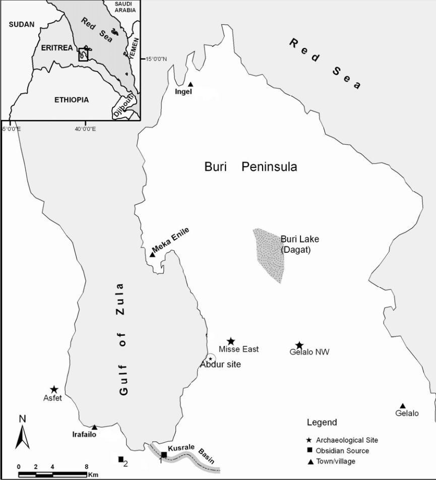
A crucial part of understanding the significance of the obsidian artifacts involved geochemical analysis. This analysis was performed on six obsidian fragments previously gathered from Mersa Gawasis. The objective was to compare these fragments with those from potential source areas across the Horn of Africa and the Arabian Peninsula, specifically from sites in Eritrea, Ethiopia, and Yemen.
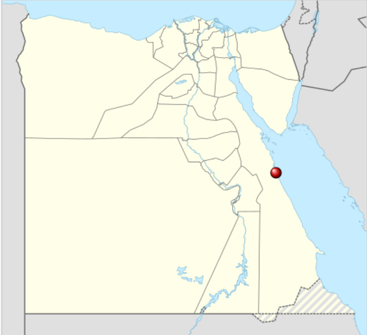
The results of this comparison were enlightening. Among the sites sampled, Kusrale in Eritrea was identified as the most likely source of five of the six analyzed obsidian artifacts from Mersa Gawasis(Source).
Map depicting Kusrale, Eritrea (At The Bottom Center). (Source)
One of the names given to the Puntites was Khebsi, it was more commonly used during the later dynastic periods of Ancient Egypt15. This term may be related to the modern-day Tigrinya word ከበሳ (Kebessa) meaning highlander/highlands, (Highlands of Eritrea).
Note: Francis Breyer suggests that the “Puntites” were also referred to as “hbstiw,” which later evolved into “hbst” during the Aksumite period. In Arabic inscriptions, this term appeared as “habasat”, leading to the modern term “habesha.” (The Ancient Egyptian Etymology of Ḥabašāt “Abessinia”, pg 11)
The highlands of Eritrea were probably one of the first places where Habeshas originated from, with the first inhabitants near the coastline near Adulis being given the name Khebsi.
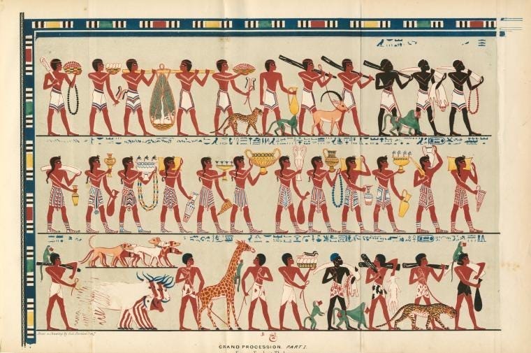
Interestingly, Ancient Egyptians commonly depicted Puntites as red/copper-toned, similar to depictions of themselves, this was in contrast to depictions of some Nubians. This can be seen vividly in the 15th Century BC mural below:
Vizier Rekhmire Grand Procession mural at Thebes, Egypt. Top row=Puntites (left), Nilotes (far right); Middle row=Cretans; Bottom row=Hamitic-type Nubians, Nilote (center-right). (Source)
Conclusion
Based on the evidence provided above, which includes the mentions of mining in Bia-Punt, genetic analysis of Papio hamadryas baboons in ancient Egypt linked to modern-day populations in Eritrea, and the analysis of obsidian fragments linked to Eritrea, we can conclude that Eritrea was, at the very least, a part of Punt, if not the central region of Punt.
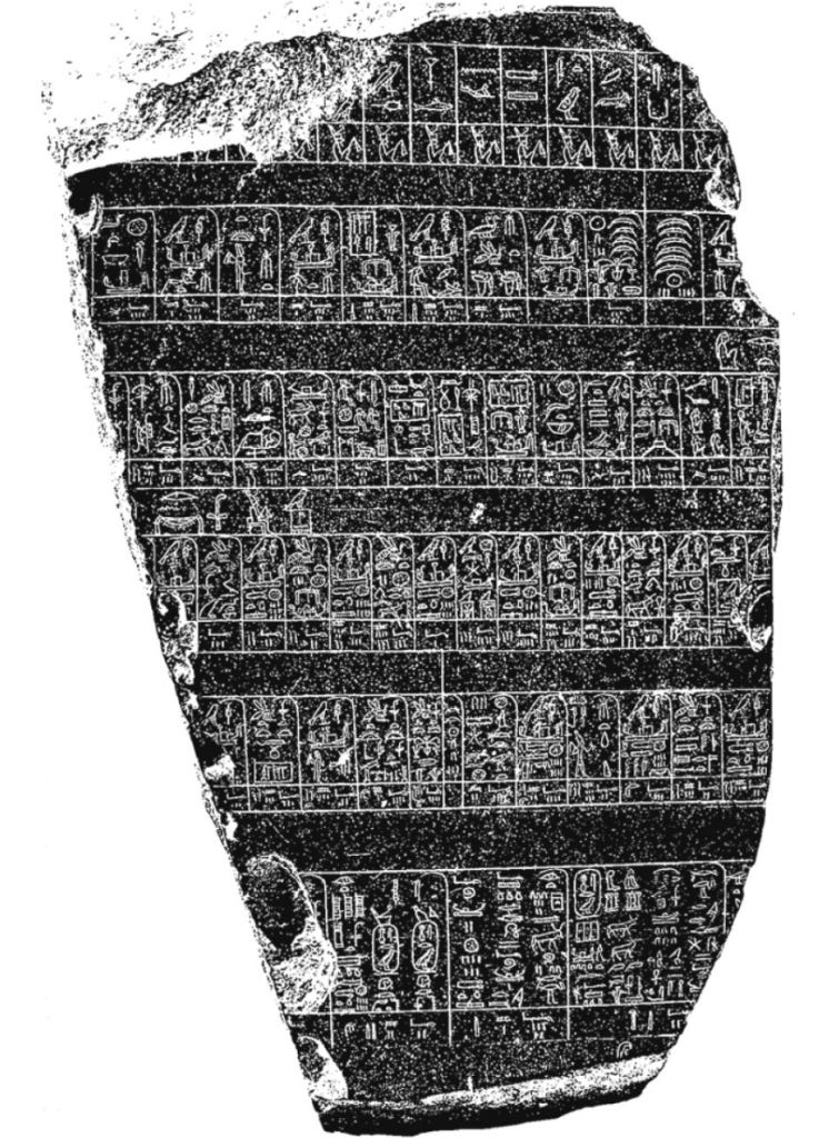
The Palermo stone is one of the seven fragments of the Royal Annals of Ancient Egypt’s Old Kingdom. It contains a list of the kings of Egypt from the First Dynasty to the Fifth Dynasty. This stone has one of the earliest known references to Punt. The hieroglyphics on the stone document several items that were brought from Punt, specifically mentioning the following:
What is electrum? Richard Pankhurt states that “Electrum usually reffered to the alloy of gold and silver, but in the context of imports from Ethiopia/or the Red Sea area it probably referred to pure gold” (The Ethiopian Borderlands, pg 5).
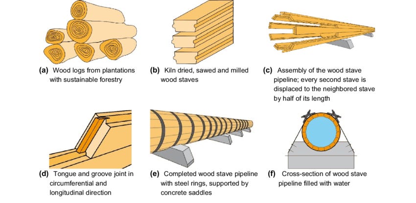
Although what is written after “staves” is not documented, we can make an educated guess that it refers to 2,600 staves made of wood.
The creation of a wood stave used for a wooden pipeline. (Source)
Harkhuf (2300BC-2150BC)
The official account of Harkhuf provides a detailed report of four expeditions that he carried out while serving two of the Sixth Dynasty pharaohs, namely Pharaoh Merenre (c. 2287–2278 BC) and Pharaoh Pepi II (c. 2278–2184 BC). In one of these expeditions, there is a mention of a previous expedition to Punt, led by ‘god’s seal-bearer Bawerded’, during the reign of Pharaoh Djedkare Izezi (c. 2414–2375 BC) in the Fifth Dynasty. Specifically, it mentions that Bawerded brought back a dancing pygmy from Punt:
This inscription suggests that slave trading was probably an activity conducted within Punt. Puntites, often depicted with a similar complexion to the Ancient Egyptians (red or copper), weren’t described as pygmies. Therefore, the pygmy depicted was likely of foreign origin, possibly from surrounding regions, and captured then sold to the ancient Egyptians.
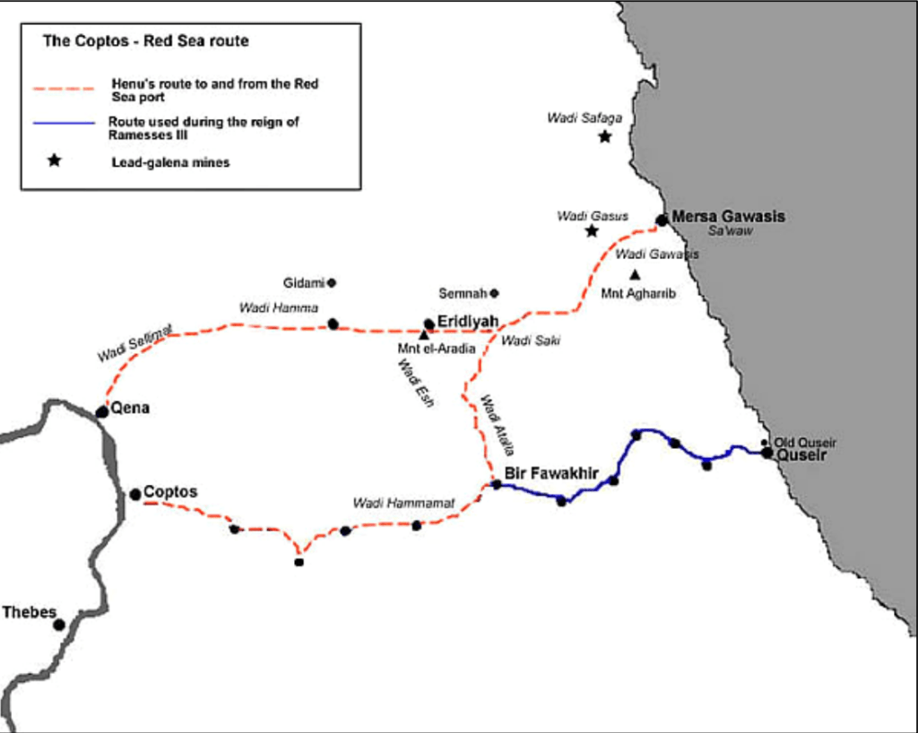
Henu (2055BC-1985BC)
In the Eleventh Dynasty, specifically from around 2055–1985 BC, during the eighth year of Pharaoh Mentuhotep III’s rule, a prominent official named Henu led a force of three thousand militia members to the Red Sea coast to supervise the construction and launching of a ship intended for an expedition to Punt. The inscriptions left by Henu confirm that such journeys to Punt through the Red Sea were indeed undertaken.
This also suggests that trade with Punt was deemed so crucial that it fell directly under the royal or pharaonic authority. The inscription reads as follows:
Interestingly, This inscription records the challenges faced by the Ancient Egyptians from nomadic tribes prior to the building of the boats for the expedition to Punt. This is probably one of the reasons why a dedicated port was created for future expeditions of Punt.
After King Mentuhotep IV (2242–2212 BC) founded the port of Mersa Gawasis, several stelae and inscribed stone anchors were discovered near the Mersa Gawasis. These artifacts date back to the reign of Sesostris I (c. 1956–1911 BC). As previously discussed these inscriptions are attributed to an official named a Ankhu. One of these inscriptions reads the following:
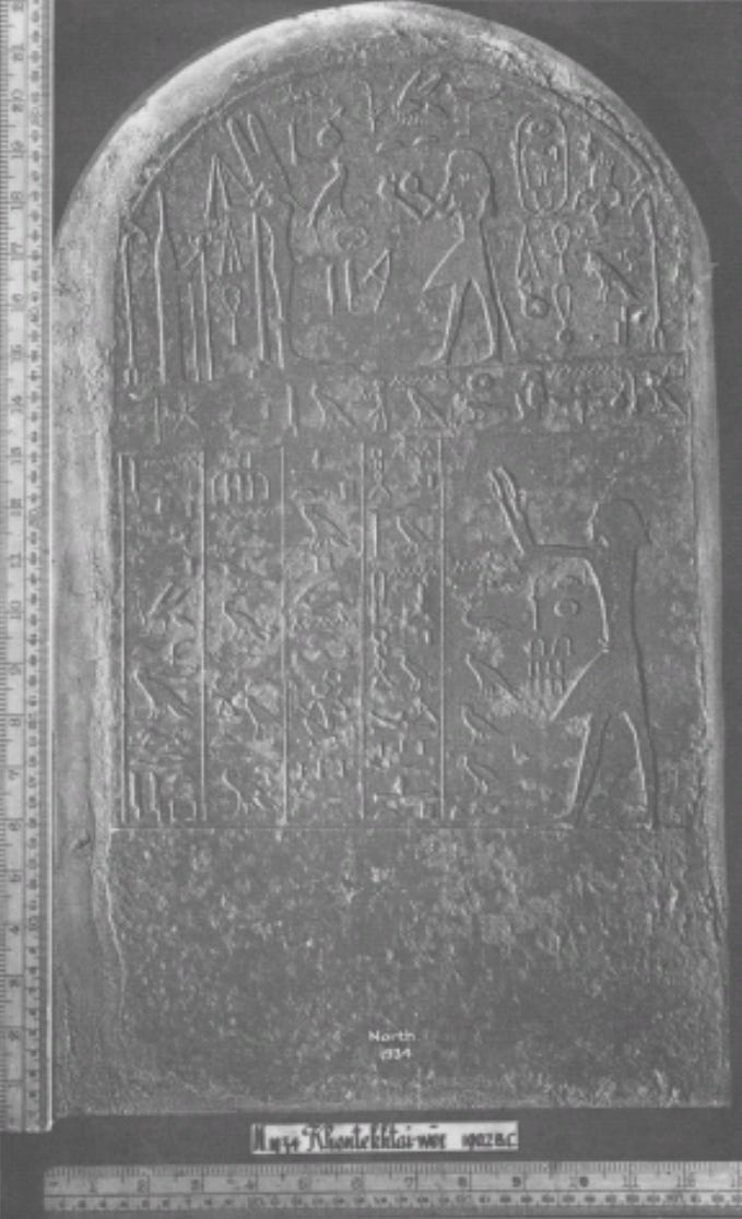
The stela of Khentkhetwer was discovered in Wadi Gasus. It is believed to have originated from a location near the Red Sea port. The stela is dated from Year 28 of the reign of Amenemhat II (c. 1911–1877 BC). It provides conclusive evidence that expeditions to and from Punt did occur from a Red Sea harbor (Sa’waw/Wadi Gasus). The Stela includes the following inscription:
Wadi Gasus and Wadi Gawasis are two separate locations, each possessing its own harbor named Mersa Gasus and Mersa Gawasis, respectively. These two sites are located within a range of 2 kilometers. In the Arabic language, ‘wadi’ signifies ‘valley’ and ‘mersa’ refers to ‘small harbour.’ (Profiling Punt : using trade relations to locate ‘God’s Land’GOD’S LAND’)
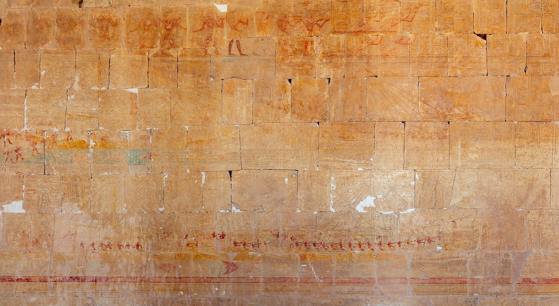
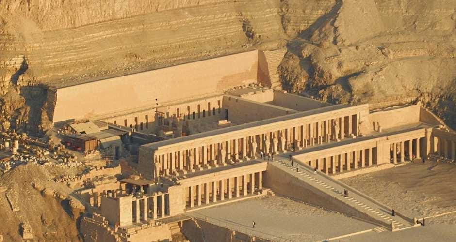
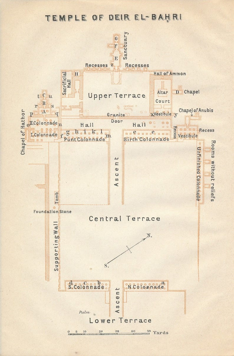
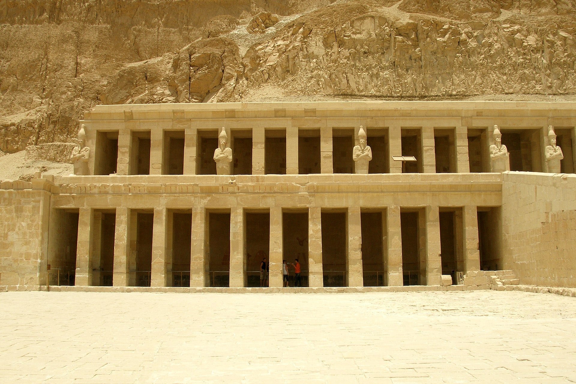
Temple of Deir al-Bahri , Queen Hatshepsut’s Temple (Source)
Pharaoh Hatshepsut, reigning from circa 1473 to 1458 BC, is one of the most fascinating figures of ancient Egypt. Known for her ambition and innovation, she chose to construct her mortuary temple in a valley previously utilized by her ancestor, Mentuhotep II, for his own temple. However, Hatshepsut’s vision was to create something far grander. Her temple, is known as Djeser-djeseru or ‘the Holiest of Holies.
The temple stands as a testament to Hatshepsut’s power and divine claim to the throne, with its walls adorned with intricate scenes from her life. These scenes are not mere decorations; they serve as historical narratives and political propaganda. They depict various significant events such as her divine birth, symbolizing her divine right to rule, the dedication of two obelisks at the temple of Amun at Karnak, representing her piety and religious devotion, and notably, her famed expedition to the land of Punt.
As per all the expeditions mentioned previously, an official, this time named Nehsi was tasked with the actual act of travelling in the expedition, Nehsi represented the Pharoah Hatshepsut in her journey.
Artwork, Featuring Nehsi & Queen Hatshepsut, upon their arrival back from Punt. (Source)
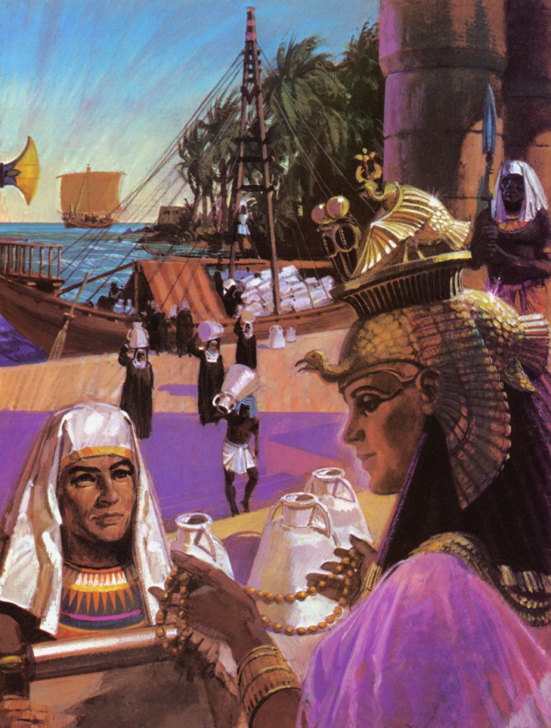
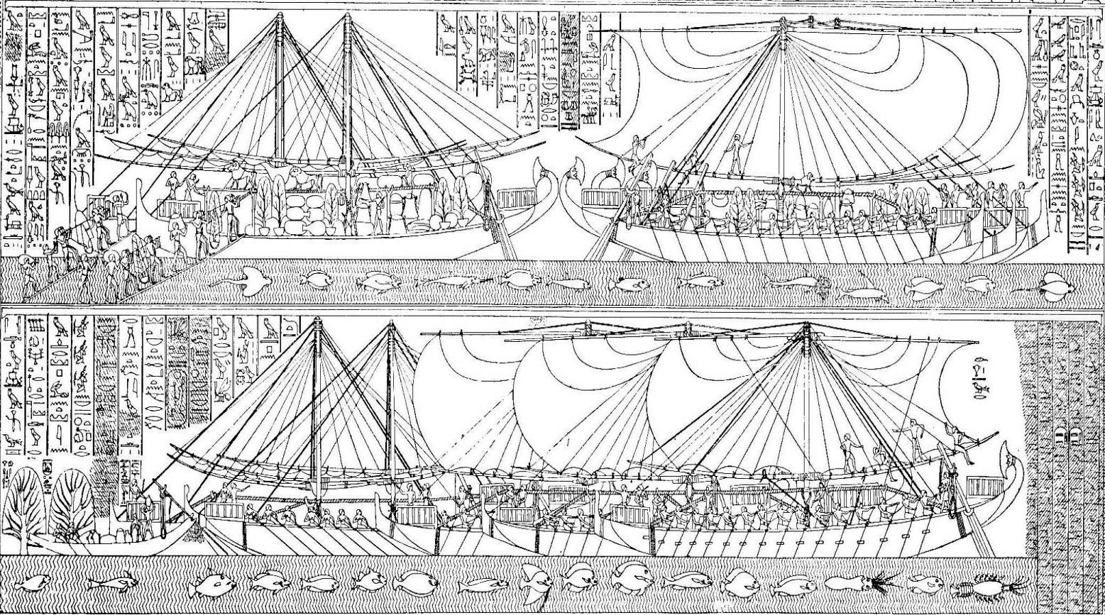
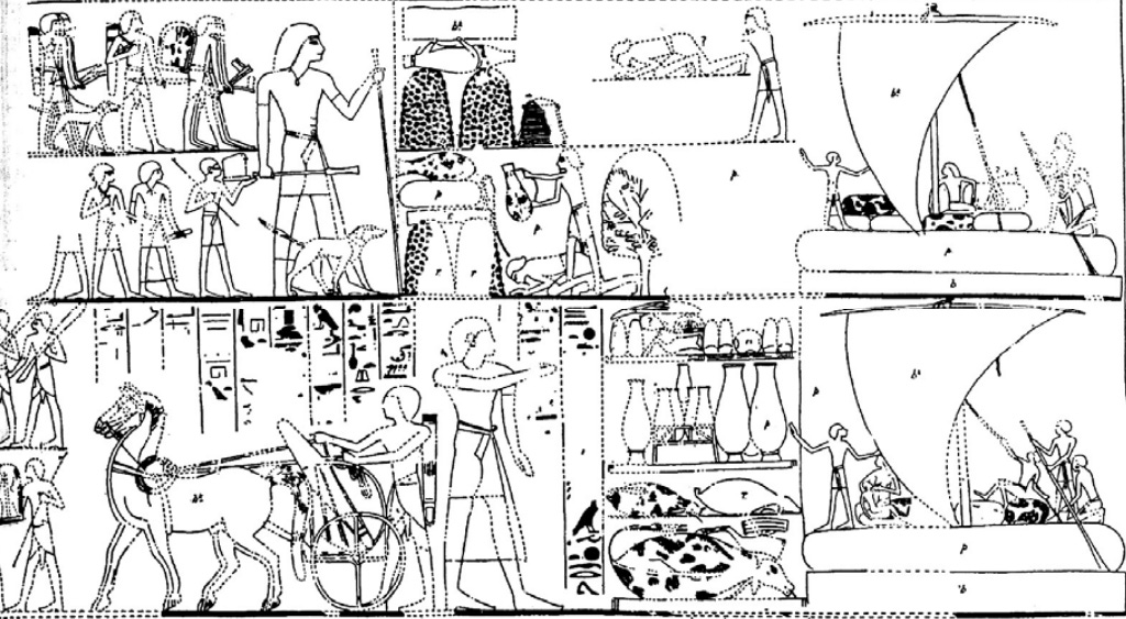
The Expedition to Punt
One of the most celebrated achievements of Hatshepsut’s reign was the expedition to Punt, officially proclaimed in the ninth year of her reign. The depiction of this expedition is prominently displayed on the southern wall of the middle colonnade on the middle terrace of her mortuary temple. According to the relief scenes, the motivation for this journey was a divine directive from the god Amun.
Luxor, Egypt 1908: Temple of Deir el-Bahari at Thebes. (Source)
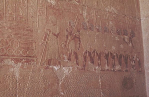
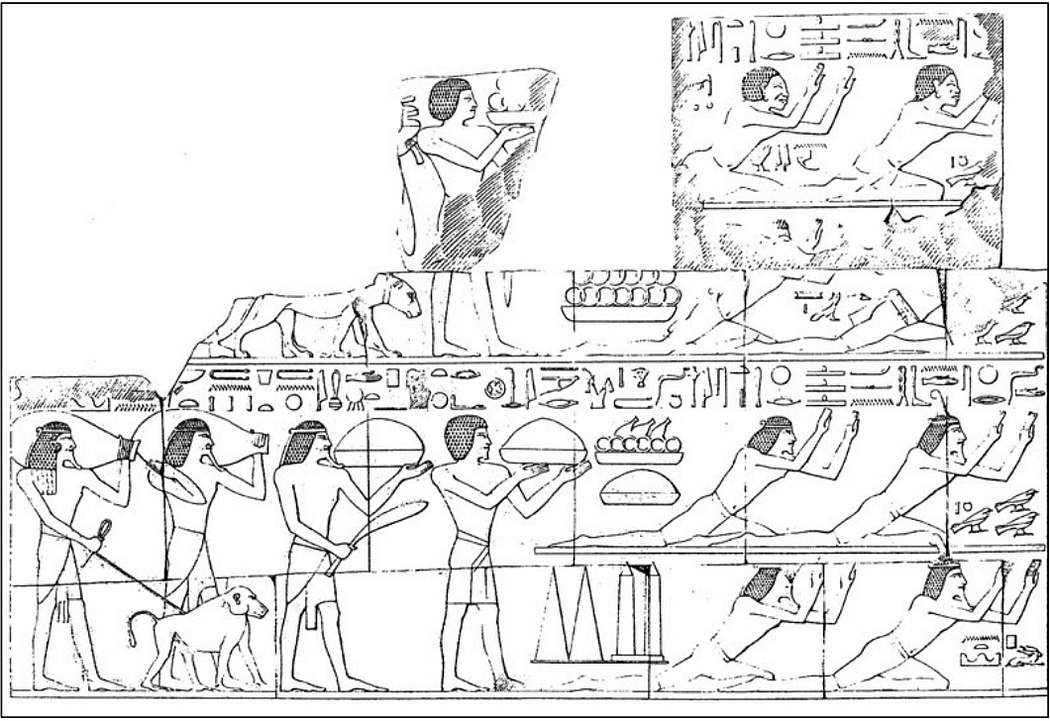
The scene on the south wall is divided into six registers that are read from the bottom to the top. The first register shows the Egyptian Envoy accompanied by an officer and eight armed soldiers. They are standing in front of goods meant for trade and gifts which include beads, an axe, a dagger and bracelets. The inscriptions on this register read as follows:
The Egyptian Enovy, an officer and eight armed soldiers. (Source)
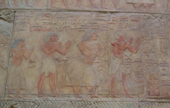
Chief of Punt, his wife and their family. (Source)
The inquiry from the Puntite about the Egyptians’ method of travel, coupled with the claim that the Egyptians lacked the knowledge to reach their lands, likely suggests a significant gap of time since the last expedition between Egypt and Punt.
On the far left of the first register, we can see the homes of Punt, and a dog squatting.
The second register, is situated above the previous depictions. In this register, the head official of Egypt is shown standing next to the tent of the Punt Chiefs. The goods from Punt that were brought for trade, such as myrrh and gold rings, are displayed next to the tent. The inscriptions located above the tent, are as follows:
The preparing of the tent for the royal messenger and his soldiers, in the harbours of frankincense of Punt, on the shore of the sea, in order to receive the chiefs of this land, and to present them with bread, beer, wine, meat, fruits and all the good things of the land of Egypt, as has been ordered by the sovereign
This specific relief suggests that trade between the ancient Egyptians and the Puntites was mutually beneficial, rather than being one-sided or coerced.
Finally, the registers at the top, which have unfortunately been damaged, show the gathering and transportation of Puntite goods such as myrrh.
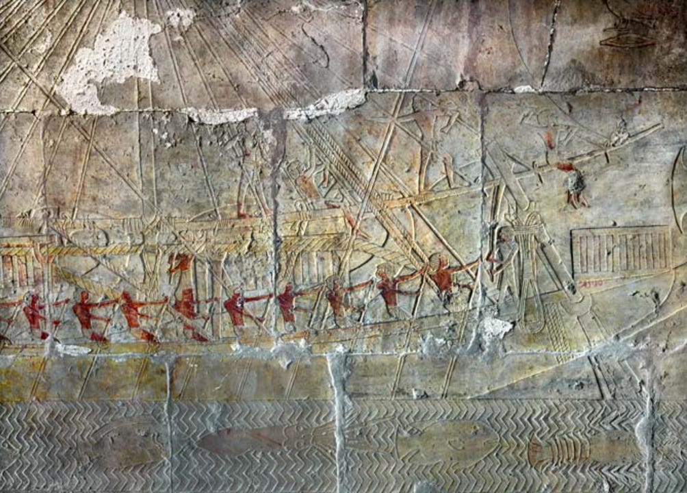
On the adjacent western wall, above the previous relief, the departure of the five Egyptian ships from Punt is shown. The inscriptions read as follows:
Clear reference to Puntites travelling with the Ancient Egyptians, back to Ancient Egypt are stated here.
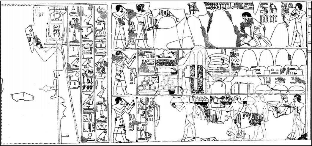
Further on the far right of the relief above, we can see the arrival of Puntite chiefs in Egypt. Specifically, in the bottom registers, the chiefs of Punt are seen giving praise to Queen Hatshepsut.
Egyptians, Puntites and other southern chiefs bringing commodities before the pharaoh Hatshepsut on the western wall in the Hatshepsut’s mortuary temple at Deir el-Bahri. The bottom two registers depict the chiefs of Punt and the upper two, the chiefs of Irem and Nmy. (Profiling Punt : using trade relations to locate ‘God’s Land’GOD’S LAND’)
Pharaoh Thutmosis III
During the reign of Thutmosis III, who ruled approximately from 1479 to 1425 BC, there were Theban tomb paintings discovered in the Valley of the Kings. These paintings provide valuable insights into the economic and diplomatic exchanges between Egypt and Punt during that era16.
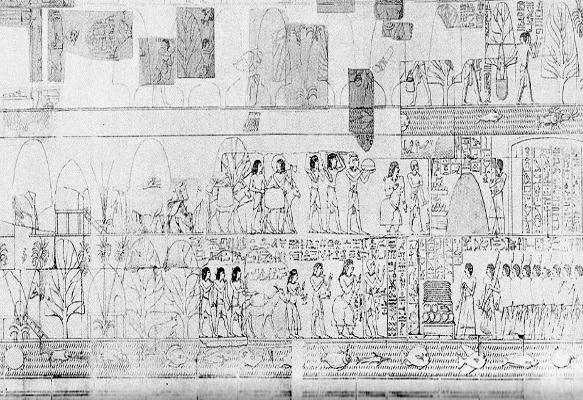
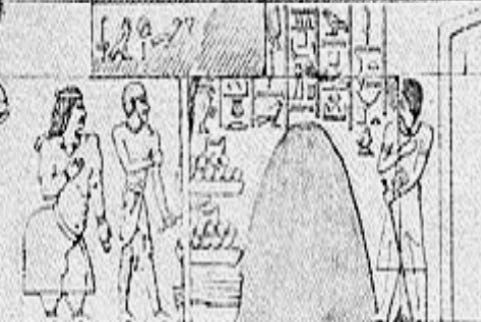
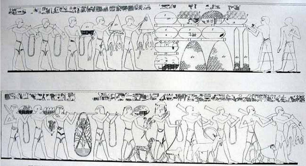
The oldest of these is the tomb of Puyemre. The scene is divided into three registers. The upper register shows scribes carefully measuring and recording heaps of myrrh.
The middle register provides a vivid representation of the various goods exchanged between Egypt and Punt, which included not only myrrh but also incense trees, ebony, and ivory tusks.
The lowest register portrays a scene that may represent the reception of a trade envoy or a tribute from Punt. This suggests that there was a form of diplomatic relationship between the two regions during that era.
Pharaoh Amenhotep II (1427–1400BC)
In the tomb of Rekhmire, who was a vizier during the reigns of Thutmosis III and Amenhotep II (around 1427–1400 BC), a similar scene of Puntite envoys carrying goods can be found.
Men from Punt Carrying Gifts, Tomb of Rekhmire. (Source)
Puntite Envoys
Further evidence supporting the theory that Puntites sent envoys to Egypt is found in another tomb, which some scholars attribute to Min, a Chief Treasurer during the reign of Amenhotep II. The tomb’s paintings include detailed scenes spread across five registers, illustrating the arrival of a Puntite envoy to Thebe17s. These depictions are significant as they provide insights into the nature of the interactions and the means of transport used by the Puntites.
These crafts are characterized by their pink bases, a single mast, and a triangular black sail, which suggest a unique design tailored to their voyaging needs. Each raft is depicted as being manned by three sailors, with a fourth individual using an oar to navigate and steer the vessel. This portrayal not only highlights the maritime capabilities of the Puntites but also suggests regular and established routes of travel between Punt and Thebes(Profiling Punt : using trade relations to locate ‘God’s Land’GOD’S LAND’).
The lower register of the tomb paintings reveals a continuation of the trade interaction. Here, an Egyptian official is depicted gesturing towards commodities of Egyptian origin, such as bread, jars (likely containing wine or beer), and packed skins, possibly filled with grain. This display of Egyptian goods suggests a reciprocal trade arrangement, where both parties benefited from the exchange of local specialties and resources.
Pharaoh Thutmosis IV (1400–1390BC)
Further evidence of Puntites travelling to Egypt can be found in the tomb of Amenmose, the Treasurer of Thutmose IV, his tomb depicts an Egyptian official arriving on a chariot to greet a Puntite envoy18.
Late Punt (1350BC-1000BC)
During the Eighteenth Dynasty, the Pharaoh Horemheb (1323–1295BC), recorded the reception of a Puntite envoy at the Temple of Karnak. The inscription reads as follows:
Although the Puntite chief asserts that they had never seen Egypt before, the previously documented expeditions suggest that previous Puntites had indeed visited Egypt. It is more probable that this statement is an exaggeration, or that it reflects the Puntite chiefs’ unfamiliarity with the Egyptian region.
Temple at Abydos
The temple at Abydos contains two inscriptions that refer to Punt, one dating to the Pharoah Seti I (1294–1279 BC). This inscription states the following:
Another inscription from the time of Rameses II(1279–1213BC), mentions Punt:
Ramses III (1217BC-1155BC)
In the Papyrus Harris I, which details the rule and achievements of Ramses III, there is a passage detailing a voyage to Punt. This expedition resulted in a significant collection of myrrh and included a child from the Punt chieftain’s family joining the voyage back to Egypt. This constitutes one of the final known mentions of Punt. The text from this record states the following:
Conclusion
After the end of the New Kingdom Period (~1050 BCE), references to Punt are virtually absent, transforming it into a mythical narrative about a distant land rich in precious commodities like essence and myrrh. There is hope for future archaeological investigations, particularly in Eritrea, Ethiopia, and Somalia, to provide deeper insights into this ancient land. It’s crucial to acknowledge that archaeological research in these areas is still in its infancy, with the potential for many more discoveries to come. The historical ties between the inhabitants of the Horn of Africa, including modern Habeshas, and the land of Punt, remain a fascinating aspect of our history and should be a source of pride.
Questions/Suggestions & Discord:
For any questions/suggestions etc, please create an account at our forum and post a thread in the Ancient History Section: https://habeshahistory.com/forums/
We have a Habesha History Discord Server, where we discuss various areas of Ethiopian and Eritrean history, all are welcome but be warned it’s in its infancy: https://discord.gg/NxdgMUDWRE
My two favourite sources for my research into Punt were as follows:
https://landofpunt.wordpress.com/tag/ancient-inscriptions/ The article, along with its accompanying website, delves extensively into the history of ancient Punt. It explores its connection to contemporary populations through genetic evidence, among many other topics, all substantiated with citations. Highly recommended for anyone seeking further information on this subject.
To provide the best experiences, we use technologies like cookies to store and/or access device information. Consenting to these technologies will allow us to process data such as browsing behaviour or unique IDs on this site. Not consenting or withdrawing consent, may adversely affect certain features and functions.
Functional
Always active
The technical storage or access is strictly necessary for the legitimate purpose of enabling the use of a specific service explicitly requested by the subscriber or user, or for the sole purpose of carrying out the transmission of a communication over an electronic communications network.
Preferences
The technical storage or access is necessary for the legitimate purpose of storing preferences that are not requested by the subscriber or user.
Statistics
The technical storage or access that is used exclusively for statistical purposes.The technical storage or access that is used exclusively for anonymous statistical purposes. Without a subpoena, voluntary compliance on the part of your Internet Service Provider, or additional records from a third party, information stored or retrieved for this purpose alone cannot usually be used to identify you.
Marketing
The technical storage or access is required to create user profiles to send advertising, or to track the user on a website or across several websites for similar marketing purposes.